Location
Mount Vernon, WA 98274

Location
Mount Vernon, WA 98274
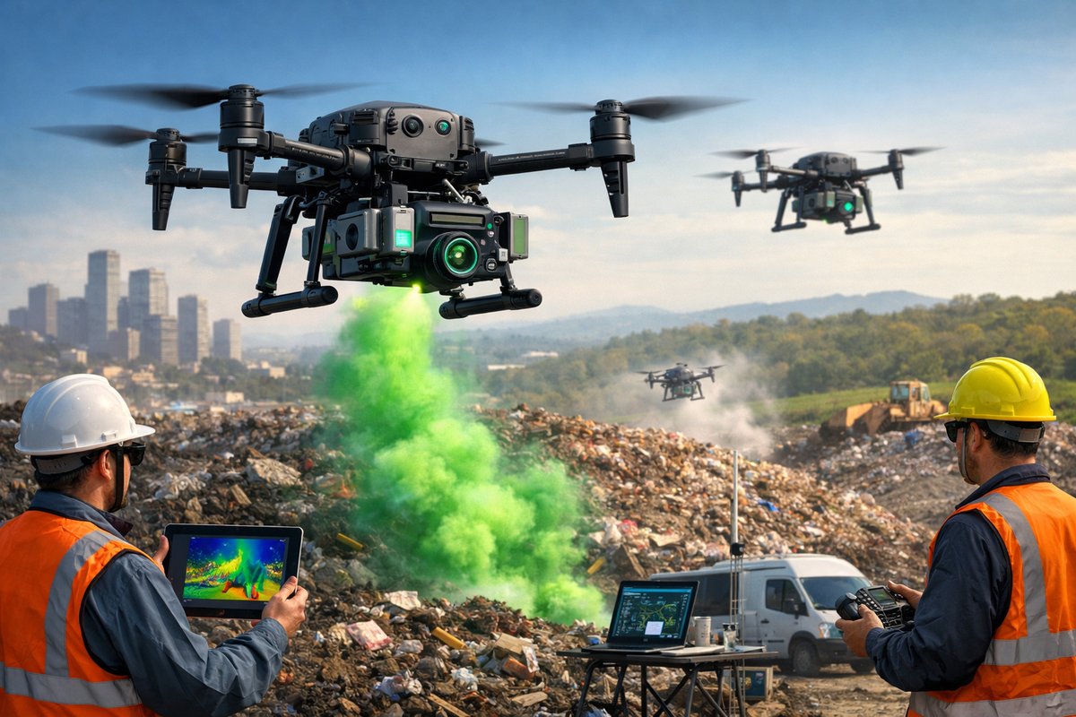
A new fleet of AI-guided drones equipped with compact spectrometers is uncovering previously undetected methane leaks at urban and rural landfill facilities. Early trials show this approach could transform how regulators, waste operators, and scientists monitor greenhouse gas emissions.
Methane, a potent greenhouse gas with more than 25 times the warming power of carbon dioxide over a century, has long eluded precise measurement in many emission hotspots. Conventional ground-based surveys and stationary sensors can miss transient leaks or struggle across rough terrain. Now, researchers and environmental engineers are deploying autonomous drones outfitted with miniaturized spectrometers and onboard analytics to map methane plumes in unprecedented detail. This breakthrough strategy aims to close monitoring gaps at landfill sites, oil and gas fields, and agricultural operations where unseen methane releases may be driving climate change faster than official inventories suggest.
In pilot studies across three major landfill locations, custom quadcopter drones flew grid patterns at altitudes ranging from 10 to 50 meters, sweeping each square meter with laser-tuned infrared beams. The spectrometer modules measure how much light is absorbed by methane molecules in real time, generating concentration maps accurate to within parts per billion. Onboard artificial-intelligence algorithms then stitch these measurements into three-dimensional emission profiles, highlighting both point sources and diffuse seepage zones. By correlating wind speed and direction data from miniature anemometers, the system can also trace detected plumes back to their ground-level origins-an essential step for pinpointing maintenance or repair needs on landfill covers and gas collection systems.
Behind this innovation lies a modular hardware design that integrates off-the-shelf drone platforms with specialized sensing attachments. Swappable spectrometer units, equipped with infrared laser diodes and compact photodetectors, weigh under 300 grams to preserve flight endurance. These plug-and-play modules can be bolted onto the drone’s payload bay, alongside auxiliary instruments such as temperature and humidity probes. Power is supplied by high-capacity lithium-polymer battery packs, offering up to 45 minutes of continuous flight even under heavy sensor loads. A low-latency data link streams raw measurements to a ground station, where custom software visualizes emission heatmaps in near real time and alerts operators when concentrations exceed predefined thresholds.
Early deployments faced challenges common to field research. Sudden gusts and unpredictable turbulence reduced GPS accuracy, sometimes forcing manual intervention. Reflective surfaces such as metal pipes or plastic sheeting created false positives in the spectrometer readings. To address these issues, teams developed reinforced propeller guards and added a secondary optical camera system to cross-validate emission hotspots. Machine-learning routines trained on thousands of flight hours now automatically filter out artifacts from glare or drone self-emissions, isolating genuine methane signals. By combining multiple sensor streams-infrared absorption spectra, visual imagery, and meteorological measurements-the system achieves robustness against environmental noise and obstructions.
In one case study at a suburban landfill, researchers discovered an unexpected leak along a trench cover where waste management crews had assumed the gas line was sealed. The drone’s mapping revealed a narrow plume stretching 15 meters downwind, with peak methane concentrations nearly three times higher than regulatory reporting thresholds. Maintenance teams used GPS coordinates provided by the flight logs to locate and re-seal a cracked valve joint, halting an estimated 2.4 metric tons of methane release per year. Similar interventions at two other sites have prevented an additional 5.8 metric tons of emissions collectively, highlighting how rapid airborne surveys can deliver quick climate benefits at a fraction of the cost of continuous stationary monitoring.
Data transparency plays a central role in this emerging methodology. All spectrometer logs, flight telemetry, wind readings, and derived emission maps are archived in an open repository accessible to municipal authorities, environmental NGOs, and independent scientists. This collaborative approach ensures that third-party experts can verify results, suggest calibration improvements, and refine detection thresholds as more flight data accumulates. A versioned API allows partners to query live or historical flights, overlay leak locations on satellite imagery, or integrate measurements into regional greenhouse-gas models. By democratizing access to high-resolution methane data, project leaders hope to catalyze broader citizen-science efforts and hold waste operators accountable to climate targets.
Beyond landfill monitoring, the drone-spectrometer concept shows promise for other sectors where fugitive methane leaks pose significant risks. Natural-gas compressor stations, pipeline corridors, and fracking sites often span remote or rugged landscapes where foot patrols are expensive and time-consuming. Urban utilities can deploy the same aerial platform to scan underground vaults and meter sets along street networks. In agricultural regions, farm cooperatives are exploring coordinated surveys of cattle feedlots, rice paddies, and manure lagoons-traditionally hard-to-measure sources in national emission inventories. By adapting module firmware and flight patterns, operators can customize the system for diverse operational requirements, from quick roadside overflights to detailed multi-altitude profiling missions.
The climate-policy implications of widespread drone-based methane mapping are profound. International agreements and carbon markets rely on accurate emissions reporting to set caps, price credits, and enforce penalties. Yet studies have shown that many countries underreport methane output from key sectors by as much as 20-30 percent. High-resolution, verifiable data streams could bolster the credibility of national inventories and inform more ambitious mitigation targets. Regulators could adopt performance-based incentives, awarding bonus credits to facilities that demonstrate sustained emission reductions validated by independent aerial surveys. At the community level, transparent leak maps empower local advocates to press for repairs and improvements, while landfill operators can fine-tune gas capture systems to maximize resource recovery and revenue from renewable natural-gas production.
Looking ahead, research teams are exploring enhancements to further shrink form factors and boost detection sensitivity. Chip-scale integrated circuits promise spectrometer footprints under 100 grams, opening the door to even smaller micro-drones capable of indoor or tunnel inspections. Advances in solid-state laser technology could broaden the detection range to additional gases such as ethane, propane, and volatile organic compounds, enabling comprehensive fugitive emissions monitoring in a single flight. Swarm coordination algorithms are also in development, allowing multiple drones to cover expansive areas simultaneously, reducing survey times from hours to minutes. On the software side, cloud-native analytics platforms will automate anomaly detection, cluster leak events by cause, and deliver predictive maintenance alerts ahead of equipment failures.
The success of this initiative illustrates how interdisciplinary innovation-melding aerospace engineering, optical physics, environmental science, and data analytics-can yield practical tools for climate action. By shining a light on hidden methane sources, these flying sensors are rewriting the playbook for emissions management and accountability. As the technology matures, widespread adoption could become a keystone in global efforts to limit warming and safeguard vulnerable communities from the impacts of climate change.
A Glimpse Beyond: As regulatory frameworks evolve and market mechanisms reward verified emission reductions, drone-based methane mapping is poised to transition from pilot projects to industry standard practice. The democratization of advanced sensing technology heralds a future where unseen greenhouse gases no longer slip through the cracks, and every plume is brought to light for the benefit of science, policy, and the planet.