Location
Mount Vernon, WA 98274

Location
Mount Vernon, WA 98274
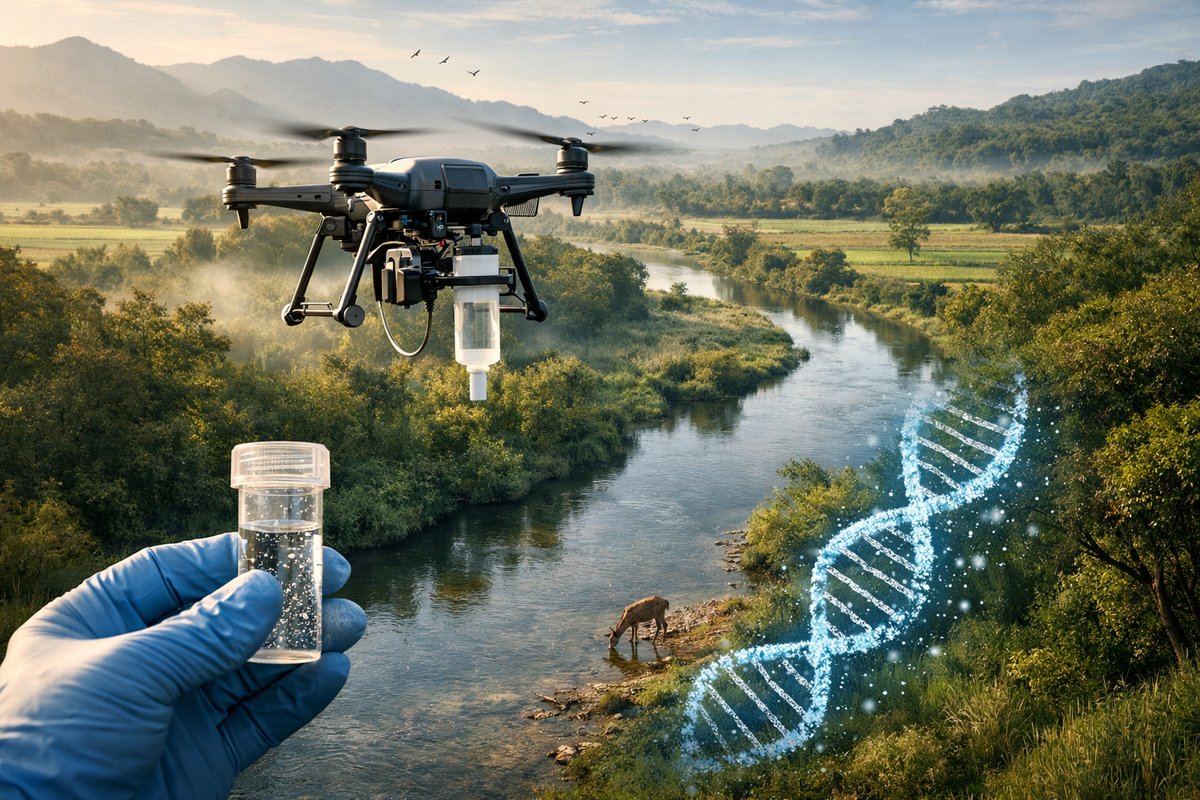
A new study employs autonomous drones equipped with environmental DNA samplers to track subtle shifts in species composition across river systems. This scalable approach uncovers biodiversity changes linked to land use and climate variation, offering conservationists a powerful new monitoring tool.
In a groundbreaking study published in a leading peer-reviewed journal, researchers have unveiled an innovative method for tracking biodiversity in freshwater environments by combining autonomous aerial drones with environmental DNA (eDNA) sampling technology. This approach captures genetic material shed by aquatic organisms into the water, enabling detailed species inventories without traditional netting or visual surveys. By pairing compact eDNA collectors with long-range drone flights, scientists were able to sample dozens of river reaches in a single morning, revealing patterns of species distribution that had remained hidden until now.
Environmental DNA has emerged over the past decade as a transformative tool for ecological monitoring. Instead of relying on manual collection or labor-intensive fieldwork, eDNA techniques isolate trace fragments of skin cells, scales, mucous, and other biological material that organisms leave behind. These genetic fragments can then be amplified and sequenced to identify species present in the environment. Until recently, however, eDNA sampling required personnel to visit each site, filter water samples on the spot, and transport them back to a lab. That laborious process has limited the spatial and temporal resolution of many biodiversity surveys.
The new study addresses these limitations by integrating lightweight sampling modules into drone platforms. Each module contains a miniaturized pumping system and a sterile filter cartridge capable of processing up to two liters of river water per flight. Once the drone hovers at low altitude over a precise GPS waypoint, the sampler lowers a flexible intake tube into the water column, pulls water through the disposable filter, and then retracts for the next waypoint. All operations are controlled by an onboard microcontroller, while real-time telemetry streams sampling status back to the pilot station.
Designing a drone capable of both stable flight over flowing water and precise sampling posed several engineering challenges. The team selected a multirotor frame with six rotors to balance payload capacity and redundancy in case of motor failure. Custom software routines compensated for wind gusts by adjusting rotor speeds in real time, ensuring the sampling tube remained submerged at a constant depth. The sampler unit itself was designed for easy sterilization and rapid cartridge exchange, allowing field teams to redeploy within minutes of landing.
Field trials took place across a 150-kilometer stretch of river in a region characterized by heterogeneous land use-ranging from forested headwaters to agriculture downstream. Over five days, two drones covered more than 120 distinct sampling points. At each location, the eDNA sampler collected water samples that were immediately preserved in a DNA-stabilizing buffer. Back at a mobile lab tent, technicians performed DNA extractions and prepared sequencing libraries for high-throughput analysis.
The study harnessed next-generation sequencing and bioinformatics pipelines to parse the massive volumes of genetic data. After quality filtering, the researchers identified DNA barcodes corresponding to over 300 freshwater species, including fish, amphibians, macroinvertebrates, and even traces of aquatic plants. Machine learning algorithms then analyzed spatial patterns in species occurrence, correlating them with environmental variables such as water temperature, turbidity, and surrounding land cover.
Results revealed clear biodiversity gradients along the river. Headwater reaches within protected forests exhibited high richness of native amphibians and macroinvertebrates, including several species of conservation concern. Further downstream, where agricultural runoff increased nutrient levels and turbidity, the data showed a marked decline in sensitive species and a rise in tolerant taxa. Seasonal comparisons-enabled by repeat drone flights over successive months-also highlighted shifts in community composition linked to precipitation patterns and water temperature fluctuations.
Beyond mapping current biodiversity, the approach uncovered early warning signals of ecosystem stress. In one agricultural tributary, for instance, the team detected eDNA signatures of invasive zebra mussels at low densities, indicating a newly established population. That finding prompted local authorities to deploy targeted physical surveys and containment measures before the mussels could spread widely. Similarly, sporadic traces of a threatened salamander species were recorded at sites previously believed to be uninhabited-information that will inform future habitat restoration efforts.
The scalable nature of drone-based eDNA sampling holds great promise for conservation monitoring at national and international scales. Traditional surveys often struggle to keep pace with rapid environmental change, especially in remote or inaccessible regions. By contrast, a network of drone operators can quickly generate dense biodiversity maps, track invasive species incursions, and assess the effectiveness of habitat protection measures. Real-time telemetry and cloud-based data processing further accelerate decision making, allowing wildlife managers to respond proactively rather than reactively.
Despite these advances, the authors acknowledge several challenges that remain. Ensuring cross-compatibility of eDNA protocols across laboratories, establishing standardized data quality metrics, and addressing regulatory concerns around drone flights all require coordinated efforts. Privacy considerations also arise when drones survey areas near private property or critical infrastructure. The study team recommends open-source software, transparent reporting of sampling metadata, and community engagement to build trust and best practices.
Looking ahead, the researchers anticipate integrating additional sensors-such as multispectral cameras, water quality probes, and acoustic recorders-into next-generation drone platforms. Such multi-modal data streams could enrich interpretations of eDNA signals by providing contextual measurements of habitat condition. Coupling artificial intelligence with these diverse datasets may unlock predictive models capable of forecasting biodiversity trends under future climate scenarios.
As environmental pressures mount worldwide, innovative tools for biodiversity assessment become ever more critical. Drone-enabled eDNA sampling offers a powerful convergence of ecological insight, engineering ingenuity, and data science. By illuminating hidden patterns of life beneath the water’s surface, this approach can guide targeted conservation actions, inform sustainable land-use planning, and ultimately help protect the intricate tapestry of freshwater ecosystems.